Art History · Learning chapter
Atlas II — Connected worlds · 7 of 10
Southeast Asian temple and court worlds, c. 600–1400: water, mountain, merit, and power
A five-site guide to how water, sacred mountains, movement, gifts, and court power shaped selected Southeast Asian temple worlds.


What we’ll look at
How did water, mountains, movement, and power shape Southeast Asian temples?
Borobudur does not offer a single façade. From the grass, it looks like a hill made geometric: broad stone terraces rise toward a crown that is visible but not immediately reachable. From a gallery, the world contracts into a passage between carved walls. Higher up, those walls release the visitor into open circular terraces, perforated stupas, sky, and distant mountains.
The monument cannot be understood from one still view because its argument is a route. Built in Central Java during the eighth and ninth centuries, it joins a natural hill, a constructed mountain, a vast field of narrative relief, hundreds of Buddha images, and a path of ascent. A visitor does not merely look at this arrangement. The visitor enters it, turns through it, and changes altitude within it.
That experience opens a larger question. Across the region now called Southeast Asia, rulers, monastic communities, donors, designers, and makers worked with religious and political forms connected to South Asia. Sanskrit travelled. So did Buddhist texts, Hindu epics, image types, ritual specialists, merchants, and courtly ideas. Yet no temple crossed the Bay of Bengal fully designed and ready to assemble. Its form had to be rebuilt in a different material, language, landscape, labour system, and field of power.
This guide asks:
How did Southeast Asian builders and patrons use water, mountain forms, movement, and gifts to make sacred landscapes into political worlds—and what disappears when their monuments are described as copies of India?
Five places provide five different answers. Borobudur turns Buddhist narrative and bodily movement into a mountain path. Prambanan translates Shaiva worship and the Ramayana into a Javanese stone compound. Angkor Wat joins a royal temple-mountain to a much larger inhabited and engineered city. Bagan makes merit visible across a river plain without reducing devotion to royal propaganda. Mỹ Sơn places Cham brick towers inside a sacred watershed whose modern ruins also bear the force of war and conservation.
These are not five stages of one civilisation. They are a route through selected histories in present-day Indonesia, Cambodia, Myanmar, and Vietnam.
What does “Southeast Asian” name here?
Southeast Asia is a modern regional category. It can help connect mainland and island histories shaped by monsoons, maritime routes, river systems, highland-lowland relations, and trade between the Indian Ocean and the South China Sea. It becomes misleading when it turns hundreds of languages, polities, religious communities, and ecologies into a single culture.
This route is selective. It cannot cover the full histories of Brunei, Cambodia, Indonesia, Laos, Malaysia, Myanmar, the Philippines, Singapore, Thailand, Timor-Leste, or Vietnam. Modern borders also do not map neatly onto medieval worlds. Angkorian power reached beyond present-day Cambodia; Cham centres stood along parts of the coast now in Vietnam; Java contained changing courts; and Bagan was linked to communities along and beyond the Ayeyarwady.
The date range c. 600–1400 is equally practical rather than natural. Mỹ Sơn began earlier, Angkor and Bagan continued to change later, and all five sites have present lives. The frame brings into view a period when courts and religious institutions used increasingly ambitious architecture, inscription, image, donation, and landscape engineering. It does not isolate a pure “Hindu-Buddhist age” from Islamic, local, ancestral, spirit, and later religious histories.
Older scholarship often described this transformation as Indianization: civilisation, religion, writing, and statecraft moving outward from India to a passive periphery. The term can identify real connections, but its directional story is too simple. The Met’s Lost Kingdoms research catalogue summarises the stronger model: ideas and forms were selectively adapted inside multicentred Southeast Asian societies, where local traditions remained active and genuinely new solutions emerged.
“Influence” therefore needs agents and verbs. Who travelled? What was carried? Who selected it? Which language translated it? What did a workshop alter? Which court or monastery gained from the new form? Resemblance begins the investigation; it does not finish it.
Borobudur: a Buddhist path built at the scale of a mountain
The UNESCO record for Borobudur dates the complex to the eighth and ninth centuries under the Shailendra dynasty. The principal monument rises around a natural hill. Five square terraces support three circular platforms and a central stupa. Seventy-two openwork stupas, each enclosing a Buddha image, occupy the upper terraces. Reliefs cover roughly 2,520 square metres of wall and balustrade.
Numbers establish scale, but movement explains the design. On the lower galleries, a visitor proceeds clockwise through long sequences of carved scenes. Bodies, buildings, ships, forests, heavens, past lives of the Buddha, moral consequences, and the young pilgrim Sudhana’s search for teachers unfold through repeated turning. The wall is not an illustrated book waiting for a stationary reader. Architecture controls how much of the sequence can be seen at once.
The upper terraces change that sensory regime. Straight walls and crowded narratives give way to circles, repeated stupas, and more open views. This has often been explained as an ascent from the realm of desire through form toward formlessness. The interpretation is useful when it remains tied to the route rather than becoming a universal key that solves every detail. Borobudur contains several textual and ritual programs, and the precise historical choreography of medieval visitors is not fully recoverable.
The monument also belonged to a larger landscape. UNESCO treats Borobudur, Mendut, and Pawon as a linked compound on an east-west axis. Mountains and volcanic activity remain materially present; drainage is essential to the stability of the hill and masonry. Twentieth-century restoration, especially the UNESCO-supported campaign of 1973–83, dismantled and rebuilt major areas to address water infiltration. The visible monument is therefore ancient fabric joined to modern engineering and conservation decisions.
That history complicates the colonial drama of “rediscovery.” Local people did not require European knowledge to know that a monument existed in their landscape. Nineteenth-century clearance, documentation, and colonial administration made Borobudur newly available to archaeology and the state, not newly existent.
Borobudur now operates as Indonesian national heritage, a mass-tourism destination, a Buddhist pilgrimage place, and an object of international conservation. Those uses overlap without being identical. A pilgrim, a conservator, a school group, and a tourism authority can all value the same stone while asking it to do different work.
Prambanan: an epic translated into Javanese stone
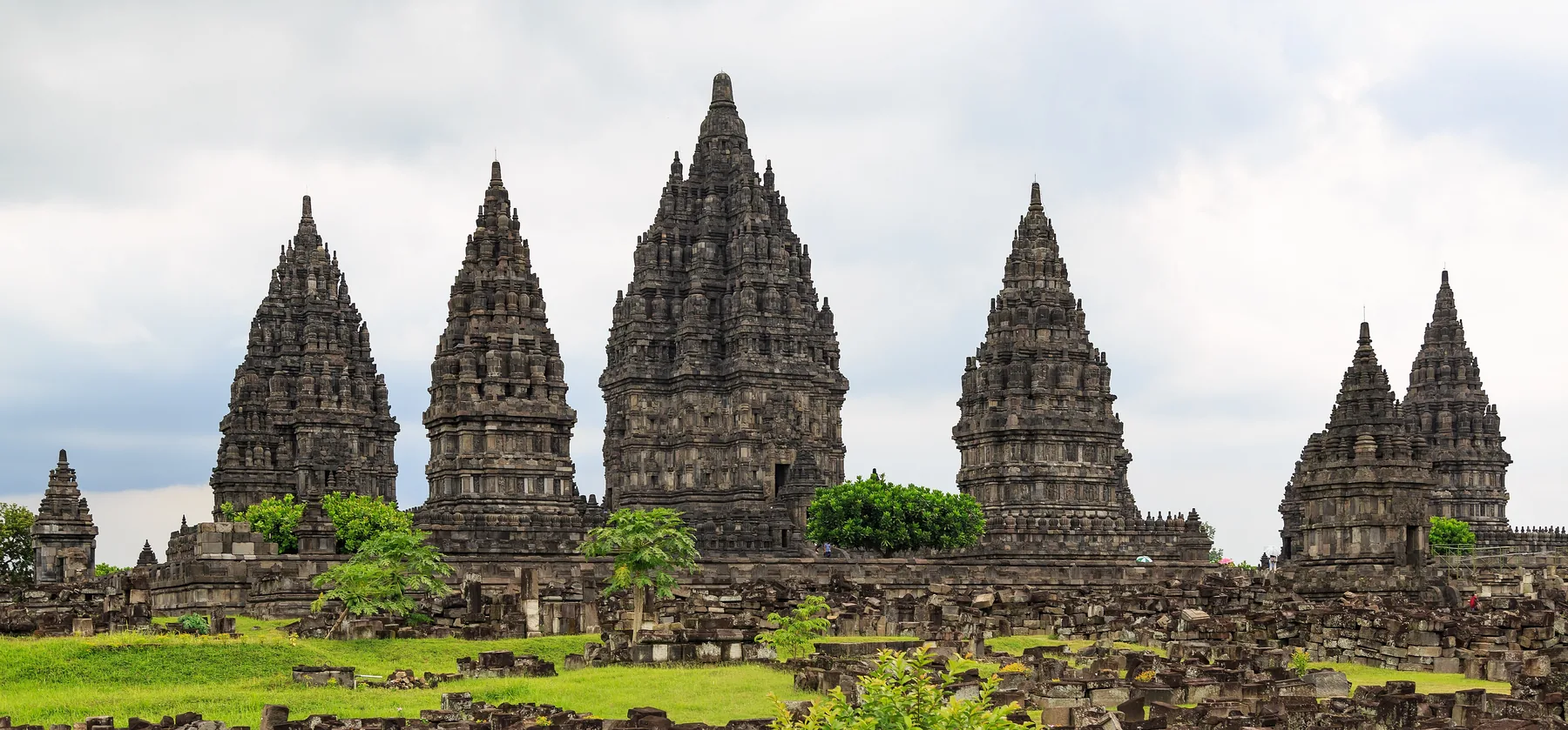

Prambanan’s central towers gather upward with a different rhythm from Borobudur. The tallest belongs to Shiva; nearby shrines are associated with Vishnu, Brahma, and their animal vehicles. Concentric enclosures and hundreds of smaller shrines organise approach toward the centre. Today, restored towers stand amid fields of disassembled stone—an unusually legible record of both monumentality and collapse.
The UNESCO Prambanan record dates the main Loro Jonggrang complex principally to the ninth and tenth centuries. It also includes nearby Buddhist compounds such as Sewu, Lumbung, and Bubrah. Their proximity matters, but it cannot by itself prove the “peaceful cohabitation” claimed in UNESCO’s official synthesis. Neighbouring institutions may indicate shared workshops, political succession, competition, appropriation, parallel patronage, or practical coexistence. Equal power and continuous harmony require evidence beyond distance on a map.
The inner balustrades of the Shiva and Brahma temples carry a long Ramayana sequence. Rama, Sita, Ravana, Hanuman, court figures, animals, forests, and battles were not carved as a facsimile of one Indian manuscript. The epic had already crossed languages and performance traditions. At Prambanan, Javanese makers arranged selected episodes for bodies moving through a specific architectural route. Plants, dress, buildings, gestures, and narrative compression gave the story a local visual world.
This is what translation looks like in stone. A translated epic remains connected to earlier tellings, but selection and placement create a new work. “The Ramayana came from India” is historically relevant. It cannot explain why these episodes appear, how one scene joins another, what a Javanese audience recognised, or how the sequence strengthened a Shaiva royal centre.
Prambanan also makes the politics of vertical form explicit. Tall superstructures marked a sacred centre visible across the plain. An enclosure sorted space and approach. Narrative joined divine order, ethical conflict, courtly conduct, and spectacle. The result could legitimise authority without becoming a simple portrait of a king.
No monument this large was produced by patronage alone. Quarrying and transporting andesite, cutting interlocking blocks, setting foundations, designing drainage, carving reliefs, raising towers, provisioning workers, and maintaining worship demanded institutions. Royal names survive more readily than masons, carriers, cooks, and ritual attendants. That archival imbalance should not be mistaken for a one-person building project.
The towers seen now record another institution: restoration. Work began in 1918 and used both traditional interlocking stone and modern reinforcement. Earthquakes and volcanic activity have repeatedly affected the compound, including the 2006 earthquake. Reconstruction makes the plan and skyline intelligible while also requiring decisions about which blocks belong, how much new support is acceptable, and whether a completed silhouette hides uncertainty.
Angkor Wat: the temple is not the whole city
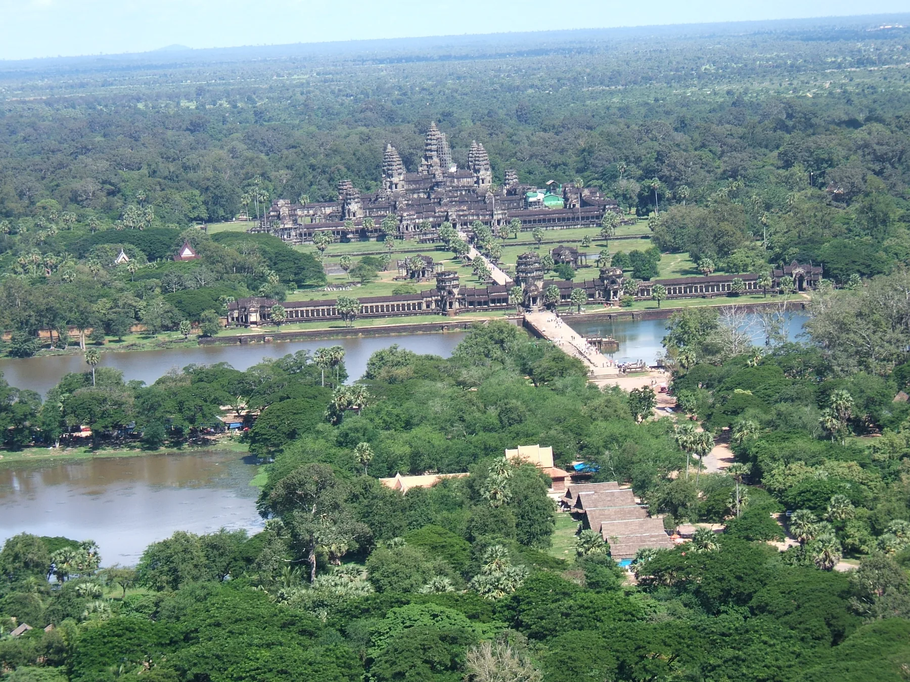

The aerial view invites an easy conclusion: Angkor Wat is an isolated stone temple surrounded by forest. It is a beautiful mistake.
The monument was part of Angkor, a changing complex of capitals, neighbourhoods, fields, roads, ponds, canals, embankments, reservoirs, temples, and perishable buildings. The UNESCO Angkor record covers roughly 400 square kilometres and explicitly includes hydraulic structures and communication routes. Archaeological mapping extends the urban network much farther than the monumental core.
Angkor Wat itself was built under King Suryavarman II in the first half of the twelfth century and dedicated to Vishnu. The APSARA National Authority’s site history places construction between 1113 and 1150 and stresses its later Buddhist use. A moat surrounds a large enclosure. A long western causeway directs entry toward three rising galleries and five central towers. Extensive reliefs include royal processions, battles, heavens and hells, and the Churning of the Ocean of Milk.
Calling it a temple-mountain helps connect vertical form to Mount Meru, the cosmic centre in Hindu and Buddhist traditions. The five towers, rising galleries, enclosure, and surrounding water could make a model of ordered space. Yet the label is an analytic tool, not the architect’s complete brief. It does not explain the temple’s unusual westward orientation, every ritual route, the political work of the reliefs, or the later Buddhist life of the building.
Water also carried more than symbolism. Across Greater Angkor, reservoirs, channels, dykes, moats, household ponds, and fields managed a monsoon environment in which too little and too much water were both dangerous. A landmark lidar study published in PNAS revealed urban features beneath vegetation and showed that hydraulic engineering belonged to extensive settlement landscapes, not only to famous stone centres.
But “hydraulic city” can become another trap if it makes water a machine that automatically produces empire. Not every channel irrigated rice; large state works operated beside household and community systems; and the functions of some mapped features remain unknown. Infrastructure depended on maintenance, negotiation, labour, and changing political priorities. Water helped stabilise settlement and display organisational power, but it did not eliminate climate risk or human choice.
The stone monument is also a biased survivor. Houses, markets, work areas, and royal buildings were often made with wood, thatch, and other perishable materials. Their disappearance can make a once-inhabited city look like a ceremonial landscape populated only by gods and kings. Archaeology restores mounds, ponds, occupation traces, ceramics, botanical evidence, and ordinary movement to the map.
Angkor Wat did not become culturally empty when court power shifted and the urban system changed. Buddhist use is documented over centuries and continues. The monument is a national emblem under Cambodian custody, a living sacred place, a major tourism economy, and a conservation site shaped by Cambodian and international institutions. Its present Buddhist presence is not an afterthought to a “real” Hindu original; it is part of the monument’s long history.
Bagan: when merit changes a river plain
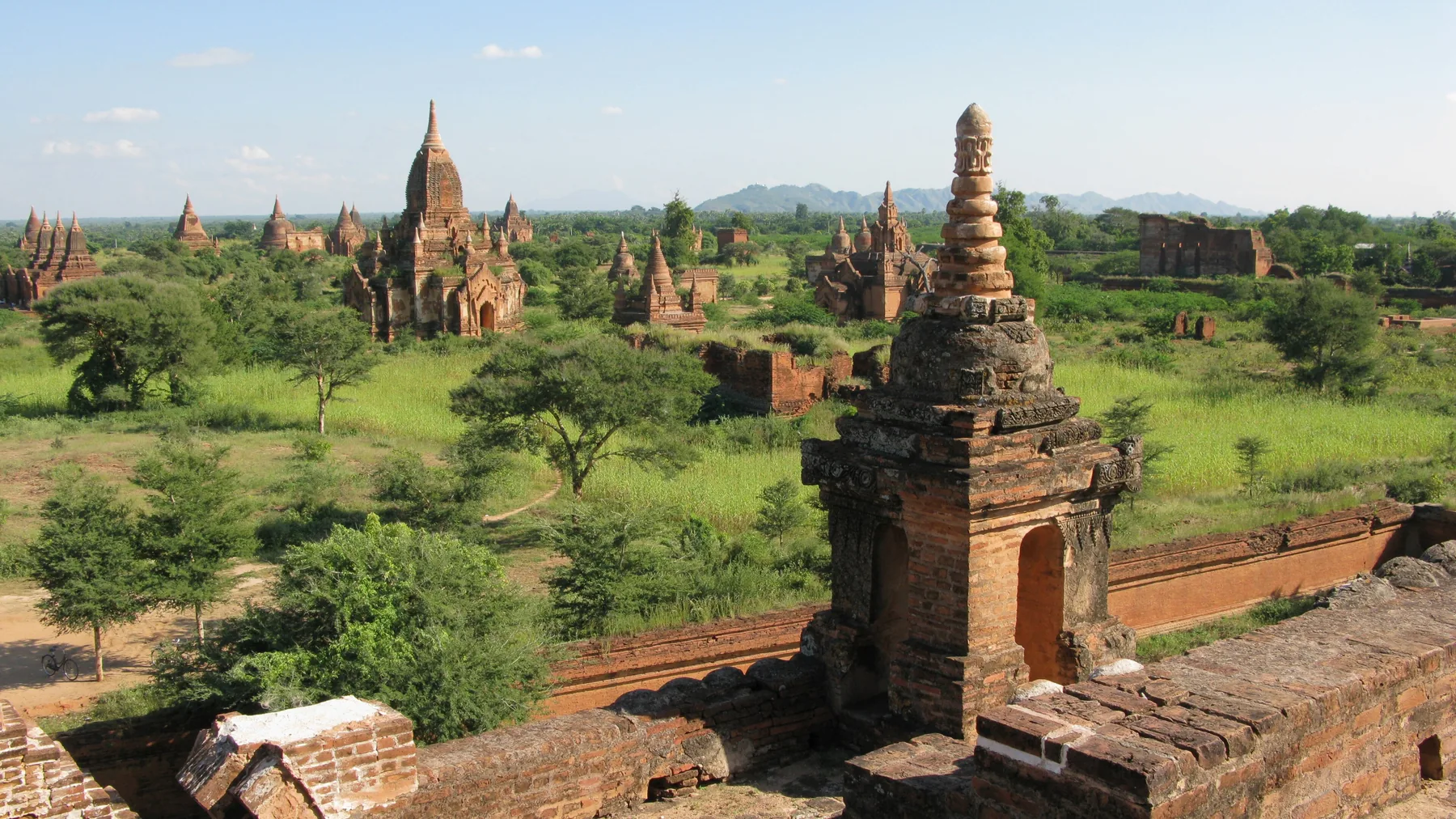

Bagan is difficult to frame because no single monument can stand for it. Across the dry-zone plain beside the Ayeyarwady, stupas, image houses, temples, monasteries, inscriptions, murals, and archaeological traces accumulate into a sacred landscape. The skyline is plural.
The UNESCO Bagan record identifies 3,595 recorded monuments and other structures within eight World Heritage components. Most belong to the eleventh through thirteenth centuries, when Bagan was the centre of a regional kingdom. The number does not count a sudden building frenzy detached from social life. It records generations of foundations, repairs, gifts, worship, competition, commemoration, and reuse.
UNESCO places merit-making at the centre of this history. In Buddhist traditions, a gift to the monastic community, the construction or repair of a sacred building, support for images and texts, or other ethically valued acts could generate merit. Donors could dedicate that merit to relatives, rulers, communities, or future wellbeing.
Merit was not a price paid for salvation. Nor was it politically innocent. A king acting as a leading donor could redistribute land and resources, bind institutions to authority, and make generosity monumental. Elites could turn wealth into visible piety and lasting memory. Monasteries received support; craftspeople and labourers produced the material field; farmers and settlements lived among the monuments. Devotion, economy, hierarchy, and power were intertwined rather than mutually exclusive.
The broad Bagan photograph may suggest a plain filled only with architecture. UNESCO instead describes a layered landscape containing living communities, farming, worship, and contemporary urban areas. A stupa can be an archaeological structure, a repaired monument, an active focus of devotion, and part of a family or village history at the same time.
Survival has been uneven. Murals darken and flake. Brick erodes. Earthquakes damage towers and vaults. Repairs undertaken in the 1970s and 1990s sometimes imposed conjectural forms or inappropriate materials, weakening authenticity even when they aimed to save buildings. The 2016 earthquake affected almost 400 monuments.
Current history must also enter the caption. On 28 March 2025, a magnitude 7.7 earthquake struck central Myanmar. UNESCO’s 2025 World Heritage Committee decision on Bagan called for damage assessment, technically reviewed repair, protection amid military activity, and support for local emergency capacity. The 2008 photograph above cannot be read as a report of the site’s present condition.
Bagan therefore makes merit visible and keeps its limits visible. A gift can support a living religious landscape. It can also consolidate status, command labour, move land, and leave some participants unnamed. Ethical value and political consequence occupy the same plain.
Mỹ Sơn: Cham brick, sacred watershed, damaged archive
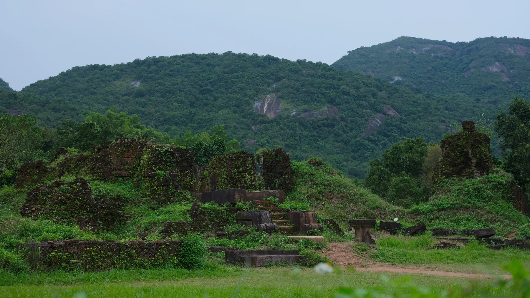

Mỹ Sơn sits inside a mountain basin that feeds the Thu Bồn River. The river passes through the historical Cham heartland and reaches the sea near Hội An. Geography connected sanctuary, defensible interior, agricultural waters, and maritime routes. The setting was not scenery selected after the temple. It was part of the institution.
The UNESCO Mỹ Sơn record traces construction from the fourth through thirteenth centuries, with much of the surviving sequence falling inside this article’s c. 600–1400 frame. Cham patrons dedicated tower sanctuaries principally to Shiva while Buddhist and other religious histories also existed within Champa. Fired brick formed the towers; stone pillars and sandstone sculpture carried thresholds, deities, guardians, narrative, and ornament.
Mount Meru again provides a vocabulary for vertical sacred form. Yet a Cham tower in this basin is not a reduced Indian temple. Brick required a different structural and surface intelligence from the stone blocks of Prambanan or Angkor Wat. Builders managed joints, heat, moisture, load, carved brick, stone insertion, and repeated rebuilding. Cham inscriptions, cults, royal genealogies, and regional exchanges gave the form a local political life.
The site belonged to networks rather than a one-way route. Sculpture at Mỹ Sơn shows relationships with South Indian Pallava art and with Khmer workshops, while maintaining distinct proportions, movement, dress, and devotional focus. Ports and river corridors connected courts, merchants, ritual specialists, texts, and objects. “Influence” was multidirectional because the region’s makers were participants, not endpoints.
Its modern name and management place the sanctuary within Vietnam. That fact should not dissolve Champa into a preface to Vietnamese national history. Cham people and practices remain present in contemporary Southeast Asia; UNESCO’s listing of Chăm pottery-making as living heritage in need of urgent safeguarding is one reminder that “Cham” is not an extinct museum label.
The ruins also contain violence. French archaeologists documented and conserved the site in the early twentieth century within a colonial knowledge system. Twentieth-century wars damaged many monuments, especially during the conflict known in Vietnam as the Resistance War against America and in the United States as the Vietnam War. Unexploded ordnance has continued to restrict research, conservation, and safe access in parts of the buffer zone.
A ruin photograph can aestheticise that loss: red brick, green vegetation, misted mountains. Historical reading asks what is absent, why it is absent, and who now bears responsibility for care. Conservation cannot restore an untouched original. It can stabilise material, record uncertainty, train specialists, and keep destruction itself in the archive.
Five landscapes, five arrangements of power
| Site | Sacred form | Water or landscape relation | Patronage and institution | What the surviving view can hide |
|---|---|---|---|---|
| Borobudur | Buddhist mountain, stupa, mandala-like route, and narrative field | Natural hill, volcanic setting, drainage, axial links to Mendut and Pawon | Shailendra-period court and Buddhist institutions; makers and medieval use incompletely recorded | Twentieth-century dismantling and reconstruction, changing pilgrimage, local knowledge obscured by “rediscovery” |
| Prambanan | Shaiva centre with high towers, concentric precincts, and epic relief | Central Javanese plain shaped by earthquakes, volcanoes, quarries, and routes | Court patronage, religious specialists, workshops, and neighbouring Hindu and Buddhist compounds | Fallen fabric, extensive reconstruction, uncertain relations between proximate communities |
| Angkor Wat | Vishnu temple-mountain, galleries, reliefs, moat, and later Buddhist place | One monumental node inside a vast inhabited hydraulic and agricultural landscape | Suryavarman II’s court, large labour and supply systems, later Buddhist custodians and communities | Perishable homes and palaces, ordinary neighbourhoods, functions of many water features, continuing sacred life |
| Bagan | Distributed field of stupas, temples, monasteries, images, murals, and inscriptions | Ayeyarwady river bend, dry-zone farming, water management, living settlements | Royal and non-royal merit-making, monastic communities, donors, makers, farmers, and worshippers | Unequal donation, conjectural repair, earthquake damage, active worship outside the tourist panorama |
| Mỹ Sơn | Cham brick tower-sanctuaries and sculpture in successive groups | Mountain basin, sacred Thu Bồn watershed, routes toward the coast | Cham courts, Shaiva institutions, regional workshops, later national and international conservation | War loss, colonial archaeology, unexploded ordnance, living Cham histories displaced by national framing |
The comparison does not reveal one ideal temple. It reveals different scales at which sacred and political order could be made visible. Borobudur concentrates a route. Prambanan concentrates a precinct. Angkor Wat concentrates one centre inside a dispersed city. Bagan distributes donation across a plain. Mỹ Sơn binds successive sanctuaries to a watershed and a dynastic homeland.
Water was symbol, infrastructure, and contested labour
Water appears in every case, but it does not mean the same thing.
At Borobudur, rain and drainage determine whether a stone mountain survives; modern conservation had to make water move through and away from its mass. At Angkor Wat, the moat frames a cosmic and royal centre, while Greater Angkor’s channels, reservoirs, ponds, and fields managed seasonal abundance and scarcity. At Bagan, river transport and dry-zone water systems supported settlement and political reach. At Mỹ Sơn, a watershed joined mountains to Cham territory and maritime access.
Calling water “sacred” cannot replace its physical work. Calling it “infrastructure” cannot remove ritual and political meaning. A reservoir may store, divert, drain, mark territory, stage a temple, or do several things over time. Its construction requires earth moving; its continued function requires maintenance; its control distributes risk and benefit.
The best question is not “Was this water practical or symbolic?” It is “How did practical operation make a political or sacred claim credible, and who kept it working?”
Sacred mountains were relationships built in space, not shapes copied into stone
Mount Meru is often introduced as the cosmic mountain at the centre of Hindu and Buddhist worlds. It helps explain rising terraces, central towers, surrounding ranges, and waters. But “symbolises Meru” can become a caption that stops looking.
Borobudur wraps a built route around a real hill. Prambanan multiplies steep towers inside ordered enclosures. Angkor Wat makes ascent, distance, gallery, moat, and central quincunx work together. Mỹ Sơn places tower-sanctuaries inside an actual mountain basin. Each uses verticality differently.
A sacred mountain was therefore not only a shape. It was a relation among height, access, direction, visibility, water, image, body, and authority. The centre mattered because paths, walls, and institutions made it a centre. The same cosmological vocabulary could legitimise a Shaiva king, organise a Buddhist path, or anchor a Cham dynastic sanctuary without producing identical buildings.
Merit and patronage moved resources
Temple patronage is often narrated as enlightened rulers giving culture to society. Donation was more complicated and more interesting.
A gift could express devotion, support monastics, maintain lamps, feed communities, sponsor images, repair a structure, secure remembrance, or dedicate merit. It could also turn land, tax, labour, and surplus into an institution aligned with power. Monumental generosity made the donor visible even when its moral language stressed self-transcendence.
Bagan preserves the most explicit landscape of merit-making in this route, but the tension belongs elsewhere too. Shailendra, Mataram, Khmer, and Cham courts used sacred foundations to organise relationships among deities, ancestors, territories, officials, specialists, and dependants. Royal patronage could be sincere religious action and political strategy at once.
The word patron should never swallow the production network. Architects, quarry workers, brickmakers, earth movers, carvers, painters, metalworkers, transporters, agricultural workers, cooks, accountants, ritual specialists, monastics, cleaners, repair crews, and communities made the monument durable. Some were paid, some obligated, some enslaved or coerced, some honoured, and many unrecorded. Grandeur is evidence of organisation, not proof that the organisation was just.
Routes carried forms; workshops made histories
Sanskrit inscriptions, Buddhist sutras, Shaiva ritual, temple plans, epics, and image types connected Southeast Asian sites to South Asia. Maritime trade and pilgrimage also linked Java, the Malay Peninsula, mainland ports, Sri Lanka, Bengal, and China. Those relations were neither a sealed bilateral exchange nor a march from centre to periphery.
Prambanan’s Ramayana becomes Javanese through selection, visual language, architecture, and later performance. Angkorian temple-mountains develop a scale and urban relation not found as a ready-made Indian prototype. Cham sculpture at Mỹ Sơn joins Pallava and Khmer connections to local bodies and cults. Borobudur’s vast narrative path is a Javanese answer to Buddhist cosmology and pilgrimage. Bagan’s merit landscape grows from Theravada practice within a specific river kingdom.
This is why “copy” fails. A copy is judged by distance from an original. A translation is judged by what it makes possible in a new situation.
Heritage is another court of power
None of the five photographs offers an unmediated medieval site.
Colonial archaeology cleared, named, classified, removed, drew, photographed, and reconstructed monuments. Modern states made them national emblems and tourism assets. UNESCO inscription added international standards and prestige. Religious communities continued or renewed worship. Conservation agencies decided which instability to tolerate, which stone to replace, how visitors should move, and which period deserved emphasis.
These actions save evidence. They also produce a new order of visibility. A completed Prambanan tower may look more historically certain than the fallen stones around it. An empty Angkor Wat photograph may erase residents and worshippers. A Bagan sunset may turn thousands of active and repaired structures into atmosphere. Vegetation at Mỹ Sơn may soften the visual fact of bombing.
Good heritage interpretation does not demand that conservation disappear. It makes intervention legible. It asks who has authority now, which communities participate, what tourism changes, and whether a site’s living religious status is treated as a management problem or a source of knowledge.
Five shortcuts to refuse
“Southeast Asian temples are Indian copies”
Religions, texts, languages, and image systems moved from South Asia, but Southeast Asian patrons and makers selected, translated, combined, and transformed them. Name the route and the borrowed form, then study the new material, audience, institution, and political use.
“Temple-mountain explains the whole building”
Meru symbolism clarifies vertical order but not every orientation, relief, route, workshop decision, or later use. A concept is strongest when it sends the viewer back to evidence.
“Water caused the state”
Hydraulic systems supported settlement, ritual, risk management, and power. They did not function automatically or alone. Climate, trade, warfare, court politics, household practice, maintenance, and ecological change also shaped cities.
“Merit means pure generosity”
Merit-making can be ethically serious and socially beneficial while also redistributing land, labour, wealth, status, and memory. Religious motivation and political consequence do not cancel each other.
“The ruin is the authentic past”
Ruins contain collapse, repair, removal, vegetation, tourism, war, earthquake, excavation, and conservation. Authenticity is not the absence of later history. It is a disciplined account of which layers survive and what each intervention changed.
A working timeline, c. 600–1400
- Fourth–sixth centuries: Early sanctuary foundations, inscriptions, and political-religious centres develop at Mỹ Sơn before this article’s main frame.
- Seventh–eighth centuries: Cham rulers continue to endow Mỹ Sơn; regional workshops connect its sculpture to multiple mainland and maritime traditions.
- Eighth–ninth centuries: Borobudur, Mendut, and Pawon are built in Central Java under Shailendra-period patronage.
- Around 800: Borobudur’s principal campaigns produce its terraced mountain, narrative galleries, Buddha images, and upper stupas.
- Ninth–tenth centuries: The Prambanan compounds take shape, including the Shaiva Loro Jonggrang centre and neighbouring Buddhist complexes.
- From 802: Angkor-period royal centres develop across the Khmer landscape through successive capitals, temples, reservoirs, roads, and settlements.
- Tenth–thirteenth centuries: Many of Mỹ Sơn’s surviving brick tower groups are built, adapted, damaged, and restored within changing Cham political worlds.
- Eleventh–thirteenth centuries: Bagan becomes a major regional capital and sacred landscape; temple construction and recorded donation expand dramatically.
- 1113–c. 1150: Suryavarman II’s reign and the principal construction period of Angkor Wat.
- Late twelfth–early thirteenth centuries: Angkorian urban, Buddhist, and monumental projects expand under Jayavarman VII, reshaping the wider capital beyond Angkor Wat.
- Thirteenth century: Monument construction at Bagan reaches a peak while donation, worship, farming, and settlement continue across the plain.
- Thirteenth–fourteenth centuries: Theravada Buddhist institutions become increasingly prominent across several mainland courts through varied local histories.
- Fourteenth–fifteenth centuries: Angkor’s urban and hydraulic systems change under climatic stress, political reorientation, and shifting trade; the region is transformed rather than suddenly emptied.
Terms for looking and reading
- Candi: An Indonesian term commonly used for Hindu and Buddhist temple or sanctuary structures; its application and historical usage vary.
- Stupa: A Buddhist sacred structure associated with relics, commemoration, teaching, and circumambulation; form and use vary widely.
- Mandala: A diagram or ordered field used in several South and Southeast Asian religious traditions; it can inform architecture without acting as a complete blueprint.
- Meru: The sacred cosmic mountain in Hindu, Buddhist, and Jain traditions; Southeast Asian builders translated its spatial ideas in distinct ways.
- Pradakshina: Respectful circumambulation, commonly clockwise, around a sacred centre.
- Ramayana: An epic with many textual, oral, theatrical, and visual versions across South and Southeast Asia; there is no single timeless image sequence.
- Shaiva: Relating to Shiva and traditions centred on his worship; not every Shaiva institution follows one doctrine or practice.
- Linga: A form through which Shiva is present and worshipped; it can also enter royal naming, genealogy, and territorial claims.
- Theravada: A major Buddhist tradition grounded in the Pali canon and diverse monastic and lay histories; it is not a uniform regional culture.
- Merit: Beneficial moral and karmic result cultivated through ethical acts, generosity, worship, support, and other practices; meanings differ across traditions.
- Baray: A modern Khmer term widely used for the large reservoirs of Angkor; the features had changing hydrological, political, and symbolic relations.
- Temple-mountain: A scholarly label for a monumental sacred centre organised through rising tiers or towers associated with cosmic mountain ideas.
- Hydraulic city: A model emphasising the relation between urban life and water-management systems; useful when it does not become a single-cause theory.
- Lidar: Airborne laser scanning that can map subtle ground forms beneath vegetation, revealing roads, mounds, ponds, canals, and other archaeological features.
- Indianization: A debated model for the adoption of South Asian religions, language, political forms, and art in Southeast Asia; “localisation” and “translation” better preserve Southeast Asian agency.
- Champa: A name used for changing Cham polities and cultural networks in parts of present-day central and southern Vietnam and neighbouring regions, not one fixed nation-state.
- Conservation: Documented action to stabilise and care for heritage; it inevitably selects materials, methods, risks, and historical priorities.
Questions to carry to the next site
- Does the photograph show one monument, a precinct, or only the stone core of a much larger settlement?
- Which modern country names are geographic aids, and which historical polities or communities need to be named instead?
- What exactly travelled: a text, ritual specialist, language, image type, technique, object, or later scholarly label?
- What did local makers change in material, scale, sequence, body, dress, landscape, or use?
- Does “temple-mountain” clarify what is visible, or has it replaced close looking?
- Is water storing, draining, irrigating, transporting, enclosing, purifying, displaying power, or doing several things?
- Who built and maintained the water system, and who benefited from its operation?
- What did a donor give—land, tax, labour, food, image, building, repair, or ritual support—and who managed it?
- Does a royal inscription identify production, or only the authority most able to record itself?
- Which structures were made of perishable material, and how does their loss distort the surviving city?
- Is current worship treated as part of the site’s history or edited out of the heritage image?
- What did earthquake, war, vegetation, archaeology, reconstruction, and tourism add to the visible surface?
Source guide
Begin with institutional site records, then test their vocabulary against specialised research. A World Heritage page is strong for boundaries, documented features, conservation history, and current management; its claims about civilisation, harmony, or authenticity still require critical reading.
- For Borobudur, UNESCO’s World Heritage record establishes dates, the three-monument compound, terraces, relief area, stupas, restoration history, drainage, and tourism pressures. Smarthistory’s Borobudur essay is useful for route, narrative, and the colonial problem of “rediscovery.”
- For Prambanan, use UNESCO’s compound record for its Hindu and Buddhist components, central shrines, reliefs, earthquake history, and reconstruction. Its language of “peaceful cohabitation” is treated here as an institutional interpretation rather than proof of equal power.
- For regional translation rather than passive Indianization, John Guy’s Met catalogue Lost Kingdoms: Hindu-Buddhist Sculpture of Early Southeast Asia surveys localisation, state formation, travel, media loss, and distinctive workshop solutions.
- For Angkor, UNESCO’s site record supplies the inhabited 400-square-kilometre World Heritage frame, hydraulic features, routes, living practice, and management. The Cambodian APSARA National Authority’s Angkor Wat history establishes royal patronage, principal dates, Vishnu dedication, temple-mountain form, and later Buddhist use.
- For the city beyond the temple, Damian Evans and colleagues’ open PNAS lidar study maps previously undocumented urban and hydraulic features while retaining uncertainty about function and avoiding the claim that every channel served intensive irrigation.
- For Bagan, UNESCO’s World Heritage record documents the eight-component sacred landscape, 3,595 recorded monuments, merit-making, living communities, repair history, and environmental risk. The 2025 committee decision provides the current earthquake, military-risk, local-capacity, and technically reviewed conservation context.
- For Mỹ Sơn, UNESCO’s site record provides the Cham chronology, Thu Bồn watershed, fired-brick and sandstone construction, Shiva focus, war damage, unexploded ordnance, and conservation framework. UNESCO’s Chăm pottery record does not explain medieval Mỹ Sơn; it confirms why Cham identity must not be written as extinct.
The five photographs were audited separately from the historical claims. Gunawan Kartapranata’s Borobudur view and CEphoto, Uwe Aranas’s Prambanan view are CC BY-SA 3.0. Shankar s.’s Angkor Wat aerial is CC BY 2.0. Vyacheslav Argenberg’s Bagan landscape is CC BY 4.0. Tycho’s Mỹ Sơn view is CC BY 3.0. Each local WebP preserves the source aspect ratio and contains no crop.
Continue the route
This chapter follows South Asian temple worlds, c. 600–1400 and art on the Silk Roads. The first traces material, movement, patronage, and ritual presence across selected South Asian sites and images; the second follows objects and ideas along changing routes. Neither makes Southeast Asia an appendix to somewhere else.
The next atlas chapter turns to Tang, Song, and Yuan China: court, monastery, landscape, ceramic, and scholar culture.
One question should travel with us: when a monument appears to embody a borrowed idea, who did the work of making that idea local—and what new world did they build with it?
Editorial record
About this article
- Author
- Publisher
- GeMarkt
- Published
- Updated
- Reviewed
- Internal source & rights check. Conducted by GeMarkt Research Review. This is an internal editorial check—not independent peer review.
- Source standard
- Art history source standardPrioritises object records and research sources, distinguishes evidence from interpretation, and states material uncertainty.
Found a claim that needs checking? Report a factual error.